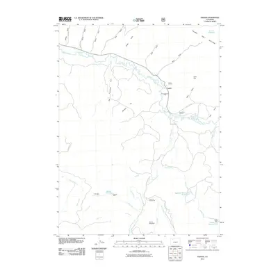
2011 Map of Pagoda
USGS Topo · Published 2011About this map
The settlement of Pagoda sits at the confluence of the Williams Fork and the South Fork Williams Fork, serving as a central hub for this high-altitude ranching and mining landscape. Local history is preserved at the Pagoda Cemetery and the Buckner-Hart Cemetery, while the industrial character of the area is evidenced by the Breeze Mountain Mine and Cedar Creek Mine. The terrain is defined by the Williams Fork Mountains and prominent heights such as Daton Peak and Round Mountain. Water management is a critical feature of the landscape, with an intricate network of irrigation and storage including the Peck Ditch, Sullivan Ditch, and Sullivan Reservoir. These features, alongside family-named landmarks like Peck Homestead Gulch and Jeffway Gulch, reflect a long-standing pattern of mountain settlement and resource utilization in Routt County.
Find a feature on this map
47 named features on this map. Tap any name to fly to it.
Don’t see what you’re looking for? This feature index may not catch every label — zoom into the map to look around manually.
Map Details
Editions of this 2011 Pagoda Map
This is the sole edition of this map. No revisions or reprints were ever made.
Other maps of this area

1910 · Danforth Hills
USGS Topo · 1:125,000

1915 · Monument Butte
USGS Topo · 1:62,500

1916 · Daton Peak
USGS Topo · 1:62,500

1920 · Daton Peak
USGS Topo · 1:62,500

1954 · Craig
USGS Topo · 1:250,000

1957 · Craig
USGS Topo · 1:250,000

1958 · Craig
USGS Topo · 1:250,000

1960 · Craig
USGS Topo · 1:250,000

1962 · Craig
USGS Topo · 1:250,000

1964 · Craig
USGS Topo · 1:250,000