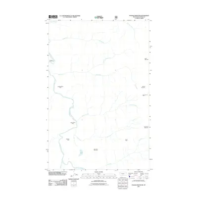
2011 Map of Pagoda Mountain
USGS Topo · Published 2011About this map
The South Fork Flathead River carves a deep path through this high-elevation wilderness in the 2010s, defining the drainage patterns for numerous tributary creeks. Along its banks, Little Salmon Park and Independence Park suggest designated areas of recreation or importance within the forest landscape. The eastern portion of the map is dominated by significant peaks, including Helen Mountain and Pagoda Mountain, the latter of which features the Pagoda Mountain Lookout. This high-vantage infrastructure, combined with the Black Bear Forest Service station, highlights the area's ongoing management for fire watch and forest protection. Smaller water features like Mud Lake and the steep descent of Damnation Creek emphasize the verticality and isolation of the terrain.
Find a feature on this map
22 named features on this map. Tap any name to fly to it.
Don’t see what you’re looking for? This feature index may not catch every label — zoom into the map to look around manually.
Map Details
Editions of this 2011 Pagoda Mountain Map
This is the sole edition of this map. No revisions or reprints were ever made.
Other maps of this area

1936 · Silvertip
USGS Topo · 1:96,000

1942 · Silvertip
USGS Topo · 1:125,000

1955 · Choteau
USGS Topo · 1:250,000

1957 · Choteau
USGS Topo · 1:250,000

1958 · Choteau
USGS Topo · 1:250,000

1962 · Choteau
USGS Topo · 1:250,000

1970 · Big Salmon Lake East
USGS Topo · 1:24,000
1970 · Cathedral Peak
USGS Topo · 1:24,000
1970 · Marmot Mountain
USGS Topo · 1:24,000
1970 · Haystack Mountain
USGS Topo · 1:24,000