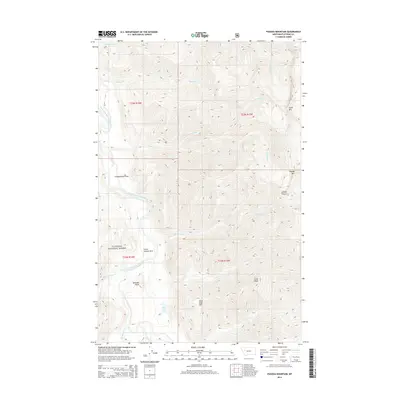
2014 Map of Pagoda Mountain
USGS Topo · Published 2014About this map
Flathead National Forest land defines this portion of Montana, where the South Fork Flathead River carves a deep valley through the wilderness. The landscape is marked by high-altitude points of interest, including the Pagoda Mountain Lookout perched near the summit of Pagoda Mtn. The drainage system is particularly dense, with numerous tributaries like Damnation Cr, Lewis Cr, and Phil Cr flowing from the surrounding peaks into the main river channel. Small, high-elevation clearings such as Independence Park and Little Salmon Park are situated along the riverbanks, providing rare level ground amidst the steep slopes of Helen Mtn and Mud Lake Mtn. This topography reflects a region managed for fire observation and backcountry recreation, centered around landmarks like Solitude Point and the basin of Mud Lake.
Find a feature on this map
24 named features on this map. Tap any name to fly to it.
Don’t see what you’re looking for? This feature index may not catch every label — zoom into the map to look around manually.
Map Details
Editions of this 2014 Pagoda Mountain Map
This is the sole edition of this map. No revisions or reprints were ever made.
Other maps of this area

1936 · Silvertip
USGS Topo · 1:96,000

1942 · Silvertip
USGS Topo · 1:125,000

1955 · Choteau
USGS Topo · 1:250,000

1957 · Choteau
USGS Topo · 1:250,000

1958 · Choteau
USGS Topo · 1:250,000

1962 · Choteau
USGS Topo · 1:250,000

1970 · Big Salmon Lake East
USGS Topo · 1:24,000
1970 · Cathedral Peak
USGS Topo · 1:24,000
1970 · Marmot Mountain
USGS Topo · 1:24,000
1970 · Haystack Mountain
USGS Topo · 1:24,000