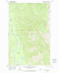
1970 Map of Pagoda Mountain
USGS Topo · Published 1973About this map
The Flathead River carves through the center of this 1970s survey, marking a corridor within the Bob Marshall Wilderness and Flathead National Forest. This remote area, characterized by its complex network of drainage basins and high summits like Pagoda Mountain and Helen Mtn, shows the backcountry infrastructure of the era. Public land management is evident through the placement of the Black Bear Guard Station and Salmon Forks Guard Station, which served as critical outposts for forest rangers and early conservation efforts.
Find a feature on this map
28 named features on this map. Tap any name to fly to it.
Don’t see what you’re looking for? This feature index may not catch every label — zoom into the map to look around manually.
Map Details
Editions of this 1970 Pagoda Mountain Map
This is the sole edition of this map. No revisions or reprints were ever made.
Other maps of this area

1936 · Silvertip
USGS Topo · 1:96,000

1942 · Silvertip
USGS Topo · 1:125,000

1955 · Choteau
USGS Topo · 1:250,000

1957 · Choteau
USGS Topo · 1:250,000

1958 · Choteau
USGS Topo · 1:250,000

1962 · Choteau
USGS Topo · 1:250,000

1970 · Big Salmon Lake East
USGS Topo · 1:24,000
1970 · Cathedral Peak
USGS Topo · 1:24,000
1970 · Marmot Mountain
USGS Topo · 1:24,000
1970 · Haystack Mountain
USGS Topo · 1:24,000