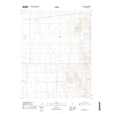
2018 Map of Pahroc Spring SE
USGS Topo · Published 2018About this map
The Burnt Springs Range dominates the eastern landscape of this Lincoln County quadrangle, where high ridges overlook the broad, arid basins of Dry Lake Valley to the northwest and Delamar Valley to the southwest. This 2018 survey reveals a terrain defined by intermittent drainage systems and vital water sources in an otherwise dry environment. Important hydrologic markers include Seven Oaks Spring and Red Rock Spring, which occur along the steep eastern slopes. Farther south, Grassy Spring sits near the head of a drainage system that feeds into the expansive Cottonwood Wash, while Red Rock Wash carves through the northern reaches of the range. The map illustrates the late-20th-century reliance on these isolated springs for land management and survival in the Great Basin region.
Find a feature on this map
13 named features on this map. Tap any name to fly to it.
Don’t see what you’re looking for? This feature index may not catch every label — zoom into the map to look around manually.
Map Details
Editions of this 2018 Pahroc Spring SE Map
This is the sole edition of this map. No revisions or reprints were ever made.
Other maps of this area

1885 · Pioche
USGS Topo · 1:250,000

1886 · Pioche
USGS Topo · 1:250,000

1954 · Caliente
USGS Topo · 1:250,000

1959 · Caliente
USGS Topo · 1:250,000

1969 · Delamar
USGS Topo · 1:24,000

1969 · Slidy Mountain
USGS Topo · 1:24,000

1969 · Delamar NW
USGS Topo · 1:24,000
1970 · Pahroc Summit Pass
USGS Topo · 1:24,000
1970 · Pahroc Spring SE
USGS Topo · 1:24,000
1970 · Pahroc Spring NE
USGS Topo · 1:24,000