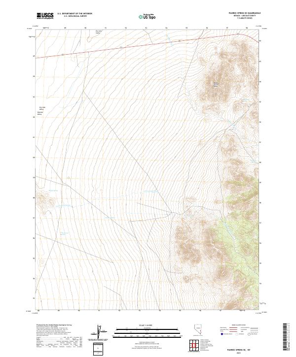
2021 Map of Pahroc Spring SE
USGS Topo · Published 2021About this map
The Burnt Springs Range dominates the eastern portion of this Lincoln County survey, providing a stark topographical contrast to the expansive desert basins on either side. To the west, the land levels out into the Dry Lake Valley and Delamar Valley, where the drainage patterns of Cottonwood Wash and Red Rock Wash define the hydrology of the arid landscape. This map is particularly valuable for locating isolated water sources essential to the region's history, including Seven Oaks Spring, Hughie Spring, and Cottonwood Springs. These sites represent the critical lifeblood of the high desert, often serving as the only landmarks for travelers and surveyors navigating the vast Nevada interior between these mountain corridors.
Find a feature on this map
16 named features on this map. Tap any name to fly to it.
Don’t see what you’re looking for? This feature index may not catch every label — zoom into the map to look around manually.
Map Details
Editions of this 2021 Pahroc Spring SE Map
This is the sole edition of this map. No revisions or reprints were ever made.
Other maps of this area

1885 · Pioche
USGS Topo · 1:250,000

1886 · Pioche
USGS Topo · 1:250,000

1954 · Caliente
USGS Topo · 1:250,000

1959 · Caliente
USGS Topo · 1:250,000

1969 · Delamar
USGS Topo · 1:24,000

1969 · Slidy Mountain
USGS Topo · 1:24,000

1969 · Delamar NW
USGS Topo · 1:24,000
1970 · Pahroc Summit Pass
USGS Topo · 1:24,000
1970 · Pahroc Spring SE
USGS Topo · 1:24,000
1970 · Pahroc Spring NE
USGS Topo · 1:24,000