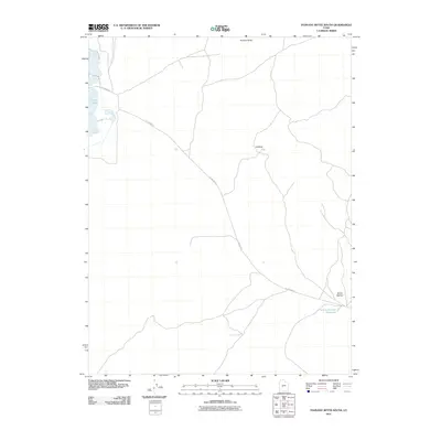
2011 Map of Pahvant Butte South
USGS Topo · Published 2011About this map
Clear Lake anchors the western edge of this arid landscape in Millard County, where water features are as scarce as they are significant. The terrain is defined by dramatic depressions and volcanic remnants, including the northern namesake Pahvant Butte and the evocative landforms of Hellhole and Devils Kitchen. In a region dominated by sagebrush and open range, the presence of the Devils Kitchen Reservoir and the North Pool Well highlights the vital infrastructure required to manage water in the high desert. The map traces the long, straight trajectory of W 1200 North, a primary artery providing access through this sparsely populated territory at the start of the 2010s.
Find a feature on this map
7 named features on this map. Tap any name to fly to it.
Don’t see what you’re looking for? This feature index may not catch every label — zoom into the map to look around manually.
Map Details
Editions of this 2011 Pahvant Butte South Map
This is the sole edition of this map. No revisions or reprints were ever made.
Other maps of this area

1885 · Beaver
USGS Topo · 1:250,000

1885 · Sevier Desert
USGS Topo · 1:250,000

1953 · Richfield
USGS Topo · 1:250,000

1953 · Delta
USGS Topo · 1:250,000

1958 · Richfield
USGS Topo · 1:250,000

1958 · Delta
USGS Topo · 1:250,000

1960 · Meadow
USGS Topo · 1:24,000

1962 · Delta
USGS Topo · 1:250,000

1962 · Fillmore
USGS Topo · 1:62,500
1962 · The Sink
USGS Topo · 1:24,000