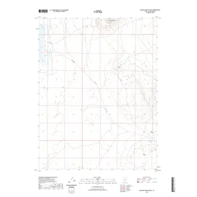
2020 Map of Pahvant Butte South
USGS Topo · Published 2020About this map
Pahvant Butte dominates the northern skyline of this Millard County landscape, a stark volcanic landmark that anchors the surrounding desert terrain. The western edge of the sheet transitions into a series of water bodies, including Clear Lake and Spring Lake, which contrast sharply with the volcanic geology found elsewhere. To the southeast, the topography descends into a collection of depressions and drainage features known as Devils Kitchen and the nearby Devils Kitchen Reservoir. The presence of The Cinders in the southern portion of the map further emphasizes the volcanic history of the region. Transportation across this arid environment is facilitated by Clearlake Rd, which cuts diagonally across the quadrangle, connecting the scattered water sources and geological formations like the Hellhole.
Find a feature on this map
8 named features on this map. Tap any name to fly to it.
Don’t see what you’re looking for? This feature index may not catch every label — zoom into the map to look around manually.
Map Details
Editions of this 2020 Pahvant Butte South Map
This is the sole edition of this map. No revisions or reprints were ever made.
Other maps of this area

1885 · Beaver
USGS Topo · 1:250,000

1885 · Sevier Desert
USGS Topo · 1:250,000

1953 · Richfield
USGS Topo · 1:250,000

1953 · Delta
USGS Topo · 1:250,000

1958 · Richfield
USGS Topo · 1:250,000

1958 · Delta
USGS Topo · 1:250,000

1960 · Meadow
USGS Topo · 1:24,000

1962 · Delta
USGS Topo · 1:250,000

1962 · Fillmore
USGS Topo · 1:62,500
1962 · The Sink
USGS Topo · 1:24,000