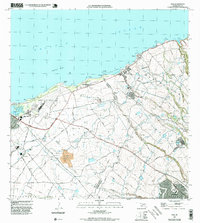
1997 Map of Paia
USGS Topo · Published 1999About this map
The coastal landscapes and agricultural districts of northern Maui are documented here during the late 1990s, where the northern shore meets the rolling plantation lands. Along the coastline, the towns of Lower Paia and Kuau serve as hubs for the surrounding area, with Baldwin Park and Hookipa Park marking popular oceanfront reaches near the Spartan Reef. The infrastructure of the sugar industry remains a dominant feature of the interior, evidenced by an extensive network of ditches, reservoirs, and pumping stations that supported the fields surrounding Puunene and Halimaile.
Find a feature on this map
52 named features on this map. Tap any name to fly to it.
Don’t see what you’re looking for? This feature index may not catch every label — zoom into the map to look around manually.
Map Details
Editions of this 1997 Paia Map
This is the sole edition of this map. No revisions or reprints were ever made.
Other maps of this area

1954 · Maui
USGS Topo · 1:250,000

1954 · Maalaea
USGS Topo · 1:24,000

1954 · Paia
USGS Topo · 1:24,000

1954 · Puu O Kali
USGS Topo · 1:24,000

1955 · Wailuku
USGS Topo · 1:24,000

1955 · Kahakuloa
USGS Topo · 1:24,000

1957 · Kilohana
USGS Topo · 1:24,000

1957 · Haiku
USGS Topo · 1:24,000

1966 · Maui
USGS Topo · 1:250,000

1974 · Maui
USGS Topo · 1:250,000