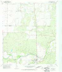
1967 Map of Paint Rock
USGS Topo · Published 1970About this map
The Concho River winds through this West Texas landscape, serving as the focal point for the settlement of Paint Rock. This 1967 field-checked survey reveals a rural community where the river's path is marked by archaeological and industrial significance, notably the Indian Pictographs located just west of the town site. The map records the infrastructure of the era, from the municipal Filtration Plant and Gaging Sta on the riverbank to the small Landing Strip nestled in the hills to the west.
Find a feature on this map
22 named features on this map. Tap any name to fly to it.
Don’t see what you’re looking for? This feature index may not catch every label — zoom into the map to look around manually.
Map Details
Editions of this 1967 Paint Rock Map
2 editions found
Other maps of this area

1891 · Hayrick
USGS Topo · 1:125,000

1892 · San Angelo
USGS Topo · 1:125,000

1892 · Eden
USGS Topo · 1:125,000

1892 · Ballinger
USGS Topo · 1:125,000

1894 · Hayrick
USGS Topo · 1:125,000

1896 · Eden
USGS Topo · 1:125,000

1921 · Lowake
USGS Topo · 1:31,680

1921 · Spur Creek
USGS Topo · 1:31,680

1921 · Rowena
USGS Topo · 1:31,680

1925 · Ballinger 3-d
USGS Topo · 1:48,000