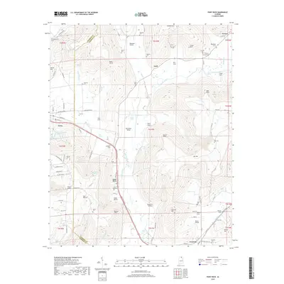
2018 Map of Paint Rock
USGS Topo · Published 2018About this map
The Paint Rock River winds through the floor of Paint Rock Valley, a region where the borders of Madison and Jackson Counties meet along a complex network of ridges and coves. The settlement of Paint Rock sits centrally along the John T Reid Pkwy, serving as a focal point near the convergence of several mountain hollows. The landscape is defined by its deep vertical relief, featuring named landmarks such as High Point, Nat Mtn, and Bingham Mtn. Local history is preserved in numerous family and community burial grounds, including Rousseau Cem, Kirk Cem, and Stewart Cem, which are tucked into the base of the surrounding heights. Transport and trade are facilitated by the railroad corridor passing through Gurley and Woodville, while the valley floor is dotted with numerous springs like Cole Spring and Daniel Spring, which have historically supported the agricultural life of these communities.
Find a feature on this map
122 named features on this map. Tap any name to fly to it.
Don’t see what you’re looking for? This feature index may not catch every label — zoom into the map to look around manually.
Map Details
Editions of this 2018 Paint Rock Map
This is the sole edition of this map. No revisions or reprints were ever made.
Other maps of this area

1888 · Scottsboro
USGS Topo · 1:125,000

1892 · Scottsboro
USGS Topo · 1:125,000

1936 · New Hope
USGS Topo · 1:24,000

1936 · Moontown
USGS Topo · 1:24,000

1936 · Hollytree
USGS Topo · 1:24,000

1936 · Grant
USGS Topo · 1:24,000

1936 · Princeton
USGS Topo · 1:24,000

1936 · Lim Rock
USGS Topo · 1:24,000

1936 · Maysville
USGS Topo · 1:24,000
1936 · Swearengin
USGS Topo · 1:24,000