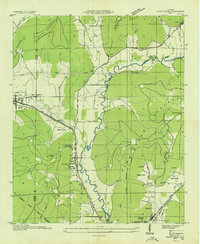
1936 Map of Paint Rock
USGS Topo · Published 1936About this map
Paint Rock River winds through a valley defined by the steep rises of the Cumberland Plateau and Keel Mountain during this 1930s survey. The Southern Railway serves as the primary transportation artery, connecting settlements like Paint Rock and Woodville to the broader Tennessee Valley region. The landscape is dotted with several family-named landmarks and essential community centers, including the Rosenwald Sch and several country churches like Shiloh Ch and the joint Antioch Ch Pleasant Grove Ch. Notable water management is evident in the Kirk Drainage Ditch, while rural industry is represented by Walkers Mill and river crossings like Flippo Ford. The presence of the Old Cherokee School Lands Boundary adds a layer of early administrative history to this Jackson County terrain.
Find a feature on this map
47 named features on this map. Tap any name to fly to it.
Don’t see what you’re looking for? This feature index may not catch every label — zoom into the map to look around manually.
Map Details
Editions of this 1936 Paint Rock Map
This is the sole edition of this map. No revisions or reprints were ever made.
Other maps of this area

1888 · Scottsboro
USGS Topo · 1:125,000

1892 · Scottsboro
USGS Topo · 1:125,000

1936 · New Hope
USGS Topo · 1:24,000

1936 · Moontown
USGS Topo · 1:24,000

1936 · Hollytree
USGS Topo · 1:24,000

1936 · Grant
USGS Topo · 1:24,000

1936 · Princeton
USGS Topo · 1:24,000

1936 · Lim Rock
USGS Topo · 1:24,000

1936 · Maysville
USGS Topo · 1:24,000
1936 · Swearengin
USGS Topo · 1:24,000