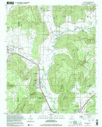
1997 Map of Paint Rock
USGS Topo · Published 2001About this map
Paint Rock River carves a deep valley through the limestone highlands of northern Alabama, serving as the central corridor for both the Southern railroad and the Lee Highway. This 1997 photo-inspection captures a landscape defined by sharp topographical contrasts, where narrow hollows like Webb Hollow and Kennamer Hollow give way to steep elevations at Bingham Mountain and McCoy Mtn. Local history is deeply embedded in the terrain through a high density of family cemeteries, including Rousseau Cem, Latham Cem, and Flanagan Cem, which mark the early homesteads of the valley.
Find a feature on this map
62 named features on this map. Tap any name to fly to it.
Don’t see what you’re looking for? This feature index may not catch every label — zoom into the map to look around manually.
Map Details
Editions of this 1997 Paint Rock Map
This is the sole edition of this map. No revisions or reprints were ever made.
Other maps of this area

1888 · Scottsboro
USGS Topo · 1:125,000

1892 · Scottsboro
USGS Topo · 1:125,000

1936 · New Hope
USGS Topo · 1:24,000

1936 · Moontown
USGS Topo · 1:24,000

1936 · Hollytree
USGS Topo · 1:24,000

1936 · Grant
USGS Topo · 1:24,000

1936 · Princeton
USGS Topo · 1:24,000

1936 · Lim Rock
USGS Topo · 1:24,000

1936 · Maysville
USGS Topo · 1:24,000
1936 · Swearengin
USGS Topo · 1:24,000