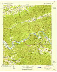
1940 Map of Paint Rock
USGS Topo · Published 1954About this map
The French Broad River snakes through the borderlands of Tennessee and North Carolina in this 1940 survey, providing a vital transport corridor for the Southern railroad. The rugged terrain of Houston Mountain and Brushy Mountain isolates small communities like Paint Rock and Harmony Grove, where life centered around local landmarks such as Timber Ridge Ch and Antioch.
Find a feature on this map
71 named features on this map. Tap any name to fly to it.
Don’t see what you’re looking for? This feature index may not catch every label — zoom into the map to look around manually.
Map Details
Editions of this 1940 Paint Rock Map
4 editions found
Other maps of this area

1883 · Morristown
USGS Topo · 1:125,000

1892 · Greeneville
USGS Topo · 1:125,000

1893 · Mt Guyot
USGS Topo · 1:125,000

1893 · Morristown
USGS Topo · 1:125,000

1894 · Asheville
USGS Topo · 1:125,000

1895 · Morristown
USGS Topo · 1:125,000

1896 · Greeneville
USGS Topo · 1:125,000

1901 · Asheville
USGS Topo · 1:125,000

1904 · Greeneville
USGS Topo · 1:125,000

1912 · Mt Guyot
USGS Topo · 1:125,000