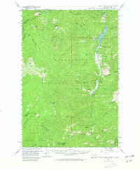
1960 Map of Painted Rocks Lake
USGS Topo · Published 1980About this map
Bitterroot National Forest and Salmon National Forest meet along the dramatic crest of the Montana-Idaho border in this 1960 field-checked survey. The landscape is defined by the West Fork of the Bitterroot River, which flows north through the narrow valley floor toward Painted Rocks Lake. This waterway serves as the primary artery for local life, supporting small mountain settlements like Alta and the Fales Flat area. Evidence of early industry and passage is scattered throughout the high country, from the Claypits in the north to the Copper Queen Mine near the southern boundary.
Find a feature on this map
69 named features on this map. Tap any name to fly to it.
Don’t see what you’re looking for? This feature index may not catch every label — zoom into the map to look around manually.
Map Details
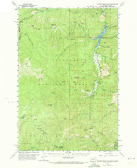
Editions of this 1960 Painted Rocks Lake Map
3 editions found
Other maps of this area

1956 · Elk City
USGS Topo · 1:250,000

1960 · Elk City
USGS Topo · 1:250,000

1960 · Painted Rocks Lake
USGS Topo · 1:62,500

1960 · Ulysses Mtn
USGS Topo · 1:62,500

1960 · Shoup
USGS Topo · 1:62,500

1960 · Piquett Mountain
USGS Topo · 1:62,500

1962 · Blue Joint
USGS Topo · 1:24,000

1962 · Horse Creek Butte
USGS Topo · 1:24,000

1962 · Nez Perce Peak
USGS Topo · 1:24,000

1964 · Boulder Peak
USGS Topo · 1:24,000