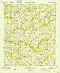
1949 Map of Painter
USGS Topo · Published 1949About this map
Sand Mountain dominates this landscape in the late 1940s, characterized by a dense network of rural churches and family-named creek crossings. The settlement of Painter serves as a central hub on the plateau, surrounded by smaller communities like Lathamville and Kilpatrick. The Tennessee Valley Authority's field examinations in 1947 reveal a region defined by its reliance on specific water crossings, including Green Ford Bridge, Luther Bridge, and Kirby Bridge over Scarham Creek. Local history is deeply etched into the topography through a high concentration of country sanctuaries like Old Macedonia Ch and Gilbreath Chapel, alongside family burial grounds such as Dalrymple Cem and Forester Cem. The boundary between Marshall and De Kalb counties cuts through the western ridge, marking a transition from the elevations of Pea Ridge to the winding tributaries of Shoal Creek.
Find a feature on this map
57 named features on this map. Tap any name to fly to it.
Don’t see what you’re looking for? This feature index may not catch every label — zoom into the map to look around manually.
Map Details
Editions of this 1949 Painter Map
2 editions found
Other maps of this area

1885 · Gadsden
USGS Topo · 1:125,000

1888 · Gadsden
USGS Topo · 1:125,000

1892 · Gadsden
USGS Topo · 1:125,000

1893 · Fort Payne
USGS Topo · 1:125,000

1895 · Gadsden
USGS Topo · 1:125,000

1898 · Fort Payne
USGS Topo · 1:125,000

1900 · Fort Payne
USGS Topo · 1:125,000

1903 · Gadsden
USGS Topo · 1:125,000

1936 · Painter
USGS Topo · 1:24,000

1936 · Crossville
USGS Topo · 1:24,000