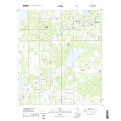
2018 Map of Paisley
USGS Topo · Published 2018About this map
Ocala National Forest dominates this section of Lake County, where dense pines and palmettos give way to a complex network of freshwater basins and swamps. The settlement of Paisley and nearby Johnsons Corner sit at the crossroads of forest roads and recreational trails, including the Florida National Scenic Trail and the Paisley Woods Mtn Bike path. This area is defined by its diverse hydrography, from the large expanse of Lake Norris and the winding Blackwater Creek to the smaller, family-named waters like Lake Lulu, Lake Jewel, and Lake Akron near the Chain O'Lakes. For those researching local burial sites or genealogical roots, the Ponceannah Cem remains a notable landmark within the protected woods. The landscape's sandy elevations are most apparent at Blue Lakes Ridge, overlooking a high concentration of named lakes that have long shaped the local economy and settlement patterns.
Find a feature on this map
121 named features on this map. Tap any name to fly to it.
Don’t see what you’re looking for? This feature index may not catch every label — zoom into the map to look around manually.
Map Details
Editions of this 2018 Paisley Map
This is the sole edition of this map. No revisions or reprints were ever made.
Other maps of this area

1954 · Daytona Beach
USGS Topo · 1:250,000

1955 · Orlando
USGS Topo · 1:250,000

1957 · Orlando
USGS Topo · 1:250,000

1958 · Orlando
USGS Topo · 1:250,000

1958 · Daytona Beach
USGS Topo · 1:250,000

1960 · Sorrento
USGS Topo · 1:24,000

1962 · Orlando
USGS Topo · 1:250,000

1962 · Pine Lakes
USGS Topo · 1:24,000

1962 · Lake Woodruff
USGS Topo · 1:24,000

1964 · Daytona Beach
USGS Topo · 1:250,000