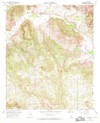
1968 Map of Pala
USGS Topo · Published 1970About this map
The Asistencia de San Antonio de Pala stands as a focal point in this San Diego County landscape, serving as a historic sub-mission along the San Luis Rey River. This mid-century survey details the complex geography of the Pala Indian Reservation and the Mission Indian Reserve, where the terrain transitions from the river valley up the slopes of Pala Mountain and Weaver Mtn. Cultural and religious history is anchored by the Indian Cem, while the agrarian and residential character of the region is evidenced by the Agua Tibia Ranch and the small settlement of Lilac.
Find a feature on this map
52 named features on this map. Tap any name to fly to it.
Don’t see what you’re looking for? This feature index may not catch every label — zoom into the map to look around manually.
Map Details
Editions of this 1968 Pala Map
3 editions found
Other maps of this area

1893 · Escondido
USGS Topo · 1:62,500

1901 · Escondido
USGS Topo · 1:62,500

1901 · San Luis Rey
USGS Topo · 1:125,000

1903 · Ramona
USGS Topo · 1:125,000

1904 · Southern California Sheet No. 2
USGS Topo · 1:250,000

1939 · Palomar Mountain
USGS Topo · 1:62,500

1942 · Temecula
USGS Topo · 1:62,500

1942 · Escondido
USGS Topo · 1:62,500

1942 · Ramona
USGS Topo · 1:62,500

1947 · Ramona
USGS Topo · 1:62,500