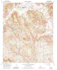
1968 Map of Pala
USGS Topo · Published 1984About this map
The Asistencia de San Antonio de Pala, a historic sub-mission, serves as the centerpiece for the settlement of Pala along the northern banks of the San Luis Rey River. Much of the landscape is defined by the Pala Indian Reservation, which encompasses Pala Mountain and stretches across rugged canyons like Couser Canyon and Double Canyon. This 1968 revision, which includes purple photogrammetric updates from 1980, shows the rural infrastructure of northern San Diego County, including the Lilac Tunnel and numerous wells and water tanks supporting local agriculture. To the south, the community of Lilac and the Hilldale area are connected by a network of winding roads such as Cole Grade Road and Mesa Verde Rd. The eastern portion of the map transitions into the Cleveland National Forest and the Agua Tibia Ranch, where the terrain rises sharply from the Pauma Valley.
Find a feature on this map
53 named features on this map. Tap any name to fly to it.
Don’t see what you’re looking for? This feature index may not catch every label — zoom into the map to look around manually.
Map Details
Editions of this 1968 Pala Map
3 editions found
Other maps of this area

1893 · Escondido
USGS Topo · 1:62,500

1901 · Escondido
USGS Topo · 1:62,500

1901 · San Luis Rey
USGS Topo · 1:125,000

1903 · Ramona
USGS Topo · 1:125,000

1904 · Southern California Sheet No. 2
USGS Topo · 1:250,000

1939 · Palomar Mountain
USGS Topo · 1:62,500

1942 · Temecula
USGS Topo · 1:62,500

1942 · Escondido
USGS Topo · 1:62,500

1942 · Ramona
USGS Topo · 1:62,500

1947 · Ramona
USGS Topo · 1:62,500