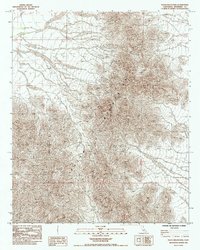
1985 Map of Palen Mountains
USGS Topo · Published 1985About this map
Palen Mountains dominate this 1980s topographic study of the California desert. The terrain is characterized by a complex network of arid ridges and dry wash systems, illustrating the dramatic geological formations of eastern Riverside County. Produced as a provisional map from 1977 aerial photography and 1978 field checks, the sheet captures the land before contemporary developments, focusing on the natural topography and the intricate drainage patterns of the desert floor. The detailed contour lines reveal the steep elevation changes across the range, providing an essential resource for understanding the physical geography of this isolated interior landscape during the late twentieth century.
Find a feature on this map
1 named feature on this map. Tap any name to fly to it.
Don’t see what you’re looking for? This feature index may not catch every label — zoom into the map to look around manually.
Map Details
Editions of this 1985 Palen Mountains Map
This is the sole edition of this map. No revisions or reprints were ever made.
Other maps of this area

1942 · Blythe
USGS Topo · 1:250,000

1945 · Midland
USGS Topo · 1:62,500

1952 · Midland
USGS Topo · 1:62,500

1952 · Mc Coy Spring
USGS Topo · 1:62,500

1952 · Sidewinder Well
USGS Topo · 1:62,500

1952 · Palen Mountains
USGS Topo · 1:62,500

1954 · Salton Sea
USGS Topo · 1:250,000

1955 · Salton Sea
USGS Topo · 1:250,000

1959 · Salton Sea
USGS Topo · 1:250,000

1963 · Salton Sea
USGS Topo · 1:250,000