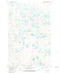
1981 Map of Palermo NE
USGS Topo · Published 1981About this map
The National Waterfowl Production Area dominates this section of the Missouri Plateau, characterized by a dense concentration of prairie potholes and wetlands. This 1981 survey by the U. S. Geological Survey illustrates the distinctive glacial topography of Mountrail County, where features like the Lowland, Crowfoot, and Reed Mound define the local drainage patterns. These names reflect the historical and geographical identity of a landscape shaped by both nature and early cattle ranching or land claims.
Find a feature on this map
14 named features on this map. Tap any name to fly to it.
Don’t see what you’re looking for? This feature index may not catch every label — zoom into the map to look around manually.
Map Details
Editions of this 1981 Palermo NE Map
This is the sole edition of this map. No revisions or reprints were ever made.
Other maps of this area

1947 · Tolley
USGS Topo · 1:62,500

1948 · Donnybrook
USGS Topo · 1:24,000

1949 · Mosquito Butte
USGS Topo · 1:24,000

1949 · Coulee
USGS Topo · 1:24,000

1950 · Kenmare
USGS Topo · 1:62,500

1950 · Tolley
USGS Topo · 1:62,500

1953 · Williston
USGS Topo · 1:250,000

1954 · Minot
USGS Topo · 1:250,000

1957 · Williston
USGS Topo · 1:250,000

1958 · Minot
USGS Topo · 1:250,000