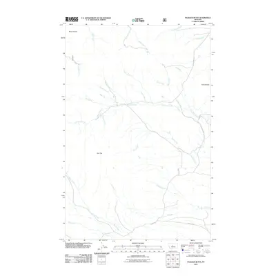
2011 Map of Palisade Butte
USGS Topo · Published 2011About this map
Palisade Butte and the surrounding high country of Chouteau County define this landscape of interconnected drainage basins and high peaks. The terrain is marked by prominent elevations like Mount Kennon and East Peak, which serve as the headwaters for a complex network of streams. Water management and natural springs, such as Jensen Spring, appear as critical landmarks in this semi-arid region. The map reveals a legacy of local passage through the hills, with Geyser Rd and Shonkin Rd skirting the base of the mountains. Of particular note to those interested in Indigenous toponymy is In-mo-is-ki Creek, which flows among more common pastoral names like Corral Creek and Shed Creek. This hydrological pattern, dominated by the winding path of Cottonwood Creek, illustrates how the geography dictated the placement of early ranching infrastructure and rural roads in central Montana.
Find a feature on this map
32 named features on this map. Tap any name to fly to it.
Don’t see what you’re looking for? This feature index may not catch every label — zoom into the map to look around manually.
Map Details
Editions of this 2011 Palisade Butte Map
This is the sole edition of this map. No revisions or reprints were ever made.
Other maps of this area

1890 · Fort Benton
USGS Topo · 1:250,000

1892 · Fort Benton
USGS Topo · 1:250,000

1897 · Fort Benton
USGS Topo · 1:250,000

1954 · Great Falls
USGS Topo · 1:250,000

1957 · Great Falls
USGS Topo · 1:250,000

1978 · Arrow Peak
USGS Topo · 1:24,000

1978 · Leiberg Coulee
USGS Topo · 1:24,000
1978 · Byrne Creek
USGS Topo · 1:24,000
1978 · Geraldine
USGS Topo · 1:24,000
1979 · Palisade Butte
USGS Topo · 1:24,000