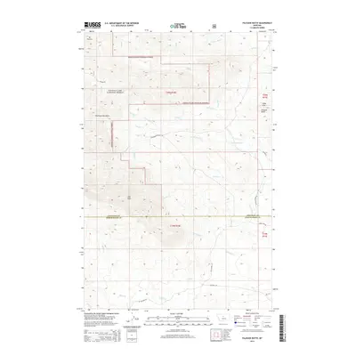
2014 Map of Palisade Butte
USGS Topo · Published 2014About this map
Highwood Mountains topography dominates this section of the Lewis & Clark National Forest, where the landscape transitions between high peaks and the drainage basins of the Missouri River watershed. High points like Mt Kennon and East Peak provide the primary vertical relief, while the eastern edge is marked by the distinct Palisade Butte and Libby Hills. The area is defined by an intricate network of waterways, including Shonkin Cr and Cottonwood Cr, which have carved deep valleys through the forest. The boundary between Chouteau and Judith Basin counties bisects the quadrangle, highlighting the administrative division of this mountainous terrain. Remote access is provided by primitive routes such as Shonkin Rd and Mt Highway 551, tracing the paths of early travel through the northern Montana ranges.
Find a feature on this map
41 named features on this map. Tap any name to fly to it.
Don’t see what you’re looking for? This feature index may not catch every label — zoom into the map to look around manually.
Map Details
Editions of this 2014 Palisade Butte Map
This is the sole edition of this map. No revisions or reprints were ever made.
Other maps of this area

1890 · Fort Benton
USGS Topo · 1:250,000

1892 · Fort Benton
USGS Topo · 1:250,000

1897 · Fort Benton
USGS Topo · 1:250,000

1954 · Great Falls
USGS Topo · 1:250,000

1957 · Great Falls
USGS Topo · 1:250,000

1978 · Arrow Peak
USGS Topo · 1:24,000

1978 · Leiberg Coulee
USGS Topo · 1:24,000
1978 · Byrne Creek
USGS Topo · 1:24,000
1978 · Geraldine
USGS Topo · 1:24,000
1979 · Palisade Butte
USGS Topo · 1:24,000