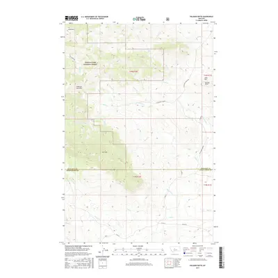
2017 Map of Palisade Butte
USGS Topo · Published 2017About this map
The Highwood Mountains dominate this 2017 survey of the borderlands between Chouteau and Judith Basin counties. The western portion of the sheet is largely contained within the Lewis & Clark National Forest, characterized by high-elevation peaks such as Mt Kennon and East Peak. The terrain is deeply incised by a complex network of drainage systems, including Shonkin Creek and the curiously named In-moolsh Creek. Moving eastward, the landscape transitions toward the Libby Hills and the prominent volcanic landmark of Palisade Butte. The road network reflects the area's rural livestock and timber heritage, with thoroughfares like Shonkin Rd and Cottonwood Creek Rd following the natural contours of the stream valleys. Water sources like Jensen Spring provide localized points of interest in an otherwise arid, high-country environment where the timber-lined creeks define the layout of the land.
Find a feature on this map
43 named features on this map. Tap any name to fly to it.
Don’t see what you’re looking for? This feature index may not catch every label — zoom into the map to look around manually.
Map Details
Editions of this 2017 Palisade Butte Map
This is the sole edition of this map. No revisions or reprints were ever made.
Other maps of this area

1890 · Fort Benton
USGS Topo · 1:250,000

1892 · Fort Benton
USGS Topo · 1:250,000

1897 · Fort Benton
USGS Topo · 1:250,000

1954 · Great Falls
USGS Topo · 1:250,000

1957 · Great Falls
USGS Topo · 1:250,000

1978 · Arrow Peak
USGS Topo · 1:24,000

1978 · Leiberg Coulee
USGS Topo · 1:24,000
1978 · Byrne Creek
USGS Topo · 1:24,000
1978 · Geraldine
USGS Topo · 1:24,000
1979 · Palisade Butte
USGS Topo · 1:24,000