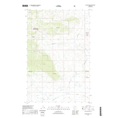
2020 Map of Palisade Butte
USGS Topo · Published 2020About this map
The Highwood Mountains dominate this section of North-Central Montana, where the elevations of the Lewis & Clark National Forest give way to the drainage basins of the plains. Significant summits including East Peak, Mt Kennon, and Prospect Peak anchor the western terrain, while the distinctive volcanic formation of Palisade Butte stands out on the eastern edge near the Libby Hills. The landscape is defined by a dense network of high-altitude water sources and seasonal drainages, including Cottonwood Creek and Shonkin Creek, which cut through the mountain front.
Find a feature on this map
67 named features on this map. Tap any name to fly to it.
Don’t see what you’re looking for? This feature index may not catch every label — zoom into the map to look around manually.
Map Details
Editions of this 2020 Palisade Butte Map
This is the sole edition of this map. No revisions or reprints were ever made.
Other maps of this area

1890 · Fort Benton
USGS Topo · 1:250,000

1892 · Fort Benton
USGS Topo · 1:250,000

1897 · Fort Benton
USGS Topo · 1:250,000

1954 · Great Falls
USGS Topo · 1:250,000

1957 · Great Falls
USGS Topo · 1:250,000

1978 · Arrow Peak
USGS Topo · 1:24,000

1978 · Leiberg Coulee
USGS Topo · 1:24,000
1978 · Byrne Creek
USGS Topo · 1:24,000
1978 · Geraldine
USGS Topo · 1:24,000
1979 · Palisade Butte
USGS Topo · 1:24,000