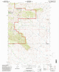
1995 Map of Palisade Butte
USGS Topo · Published 1997About this map
The Highwood Mountains dominate this 1990s landscape, marking the transition between the Lewis and Clark National Forest and the administrative reaches of the Helena National Forest. The map captures a rugged watershed defined by high peaks such as East Peak and Mount Kennon, where numerous drainages like Shonkin Creek and Cottonwood Creek carve through the terrain.
Find a feature on this map
30 named features on this map. Tap any name to fly to it.
Don’t see what you’re looking for? This feature index may not catch every label — zoom into the map to look around manually.
Map Details
Editions of this 1995 Palisade Butte Map
This is the sole edition of this map. No revisions or reprints were ever made.
Other maps of this area

1890 · Fort Benton
USGS Topo · 1:250,000

1892 · Fort Benton
USGS Topo · 1:250,000

1897 · Fort Benton
USGS Topo · 1:250,000

1954 · Great Falls
USGS Topo · 1:250,000

1957 · Great Falls
USGS Topo · 1:250,000

1978 · Arrow Peak
USGS Topo · 1:24,000

1978 · Leiberg Coulee
USGS Topo · 1:24,000
1978 · Byrne Creek
USGS Topo · 1:24,000
1978 · Geraldine
USGS Topo · 1:24,000
1979 · Palisade Butte
USGS Topo · 1:24,000