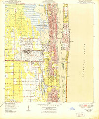
1950 Map of Palm Beach
USGS Topo · Published 1950About this map
West Palm Beach and Palm Beach dominate this mid-century coastal landscape, separated by the wide waters of Lake Worth and connected by several spans including the Flagler Memorial Bridge and Royal Palm Bridge. The mainland is characterized by a significant military and transportation presence, centered on the Morrison Field Air Base and the dual rail lines of the Florida East Coast and Seaboard Air Line.
Find a feature on this map
36 named features on this map. Tap any name to fly to it.
Don’t see what you’re looking for? This feature index may not catch every label — zoom into the map to look around manually.
Map Details
Editions of this 1950 Palm Beach Map
This is the sole edition of this map. No revisions or reprints were ever made.
Other maps of this area

1945 · Delta
USGS Topo · 1:24,000

1945 · Greenacres City
USGS Topo · 1:24,000

1945 · Lake Worth
USGS Topo · 1:24,000

1946 · Riviera Beach
USGS Topo · 1:24,000

1946 · Palm Beach Farms
USGS Topo · 1:24,000

1946 · Palm Beach
USGS Topo · 1:24,000

1949 · Lake Worth
USGS Topo · 1:24,000

1949 · Palm Beach Farms
USGS Topo · 1:24,000

1949 · Riviera Beach
USGS Topo · 1:24,000

1950 · Greenacres City
USGS Topo · 1:24,000