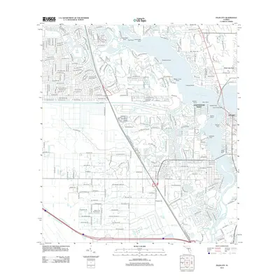
2012 Map of Palm City
USGS Topo · Published 2012About this map
The Saint Lucie River and its intricate tributaries dominate this coastal Florida landscape, where the north and south forks converge near Stuart. This 2012 survey illustrates the complex residential expansion of the early 21st century, particularly in the dense grid of streets like Palm Lake Park and the developing subdivisions of Stuart. Significant water-based infrastructure is evident, including the Roosevelt Bridge and the Stuart Southpoint Anchorage, which highlight the importance of the maritime economy. Inland, the map reveals unique local landmarks such as the Naked Lady Ranch Airport and the Fern Hill Cem. The shoreline is characterized by numerous named points, such as Lighthouse Point and Pendarvis Point, which reflect a legacy of navigation and coastal settlement along the river's winding path.
Find a feature on this map
234 named features on this map. Tap any name to fly to it.
Don’t see what you’re looking for? This feature index may not catch every label — zoom into the map to look around manually.
Map Details
Editions of this 2012 Palm City Map
This is the sole edition of this map. No revisions or reprints were ever made.
Other maps of this area

1948 · Palm City
USGS Topo · 1:24,000

1948 · Ankona
USGS Topo · 1:24,000

1948 · St. Lucie Inlet
USGS Topo · 1:24,000

1948 · Gomez
USGS Topo · 1:24,000

1948 · Eden
USGS Topo · 1:24,000

1949 · Gomez
USGS Topo · 1:24,000

1950 · St. Lucie Inlet
USGS Topo · 1:24,000

1950 · Ankona
USGS Topo · 1:24,000

1950 · Palm City
USGS Topo · 1:24,000
1950 · Eden
USGS Topo · 1:24,000