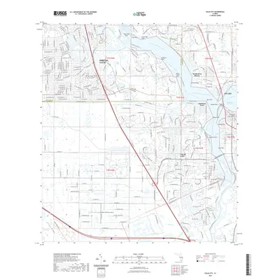
2021 Map of Palm City
USGS Topo · Published 2021About this map
Palm City and Stuart occupy a landscape defined by the branching arms of the Saint Lucie River. This modern topographic survey illustrates the density of waterfront development and residential growth along the North Fork Saint Lucie River and South Fork Saint Lucie River, where numerous points and coves like Negrohead Point and Pendarvis Cove shape the shoreline. The transition between the suburban sprawl of Port St. Lucie and the more open western lands is marked by the presence of the Naked Lady Ranch Airport and the Martin County Blueway Trl. Local heritage sites, including the Cheney Courthouse and Fern Hill Cem, stand alongside modern infrastructure and the engineered pathways of the Okeechobee Waterway. The complex network of residential canals and streets, such as SW Rattlesnake Run, demonstrates how the Florida coastline has been meticulously adapted for suburban living near the Atlantic Coast.
Find a feature on this map
201 named features on this map. Tap any name to fly to it.
Don’t see what you’re looking for? This feature index may not catch every label — zoom into the map to look around manually.
Map Details
Editions of this 2021 Palm City Map
This is the sole edition of this map. No revisions or reprints were ever made.
Other maps of this area

1948 · Palm City
USGS Topo · 1:24,000

1948 · Ankona
USGS Topo · 1:24,000

1948 · St. Lucie Inlet
USGS Topo · 1:24,000

1948 · Gomez
USGS Topo · 1:24,000

1948 · Eden
USGS Topo · 1:24,000

1949 · Gomez
USGS Topo · 1:24,000

1950 · St. Lucie Inlet
USGS Topo · 1:24,000

1950 · Ankona
USGS Topo · 1:24,000

1950 · Palm City
USGS Topo · 1:24,000
1950 · Eden
USGS Topo · 1:24,000