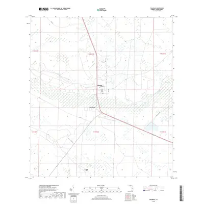
2018 Map of Palmdale
USGS Topo · Published 2018About this map
Palmdale serves as a small rural nexus in Glades County, where local streets like Main Ave and Broadway St meet near the Po. The surrounding landscape is defined by the hydrologic network of Fisheating Creek, which feeds into expansive wetlands such as Cowbone Marsh and Linden-Pens Marsh. Smaller settlements including Harrisburg and Hall City are situated along the transit corridors of Co Rd 74 and N Island Rd, marking the edge of a terrain dominated by seasonal water features. To the east, the Herbert Hoover Dike stands as a prominent engineered boundary against the marshland. This area reflects the precarious balance of South Florida's interior, where drainage features like Gopher Gully and York Branch dictate the placement of human habitation and agriculture away from the low-lying basins and lakes like Picnic Lake.
Find a feature on this map
35 named features on this map. Tap any name to fly to it.
Don’t see what you’re looking for? This feature index may not catch every label — zoom into the map to look around manually.
Map Details
Editions of this 2018 Palmdale Map
This is the sole edition of this map. No revisions or reprints were ever made.
Other maps of this area

1953 · Brighton SW
USGS Topo · 1:24,000

1956 · West Palm Beach
USGS Topo · 1:250,000

1956 · Fort Pierce
USGS Topo · 1:250,000

1957 · West Palm Beach
USGS Topo · 1:250,000

1957 · Venus
USGS Topo · 1:24,000

1957 · Venus SW
USGS Topo · 1:24,000

1958 · Fort Pierce
USGS Topo · 1:250,000

1958 · West Palm Beach
USGS Topo · 1:250,000

1958 · La Belle NW
USGS Topo · 1:24,000

1958 · Goodno
USGS Topo · 1:24,000