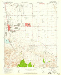
1958 Map of Palmdale
USGS Topo · Published 1959About this map
Air Force Plant 42 dominates the northern landscape of this Antelope Valley survey, reflecting the mid-century aerospace expansion in Los Angeles County. The burgeoning residential grid of Palmdale is centered around Palmdale Boulevard and the Southern Pacific tracks, showing the transition from a desert crossroads to a modern town. Educational infrastructure is well-defined by Manzanita School and Palmdale High School, serving the growing population.
Find a feature on this map
31 named features on this map. Tap any name to fly to it.
Don’t see what you’re looking for? This feature index may not catch every label — zoom into the map to look around manually.
Map Details
Editions of this 1958 Palmdale Map
3 editions found
Other maps of this area

1900 · Tujunga
USGS Topo · 1:62,500

1901 · Southern California Sheet No. 1
USGS Topo · 1:250,000

1903 · Rock Creek
USGS Topo · 1:62,500

1904 · Southern California Sheet No. 1
USGS Topo · 1:250,000

1915 · Elizabeth Lake
USGS Topo · 1:125,000

1917 · Elizabeth Lake
USGS Topo · 1:125,000

1930 · Little Rock
USGS Topo · 1:24,000

1930 · Lancaster
USGS Topo · 1:24,000

1930 · Pearland
USGS Topo · 1:24,000

1930 · West Alpine Butte
USGS Topo · 1:24,000