1954 Map of Palmer Lake
USGS Topo · Published 1955About this map
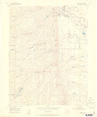
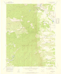
The mountain town of Palmer Lake serves as the focal point for this mid-1950s survey, showing its position along the Atchison Topeka and Santa Fe and Denver and Rio Grande Western railroads. The landscape transitions from the developed community of Glenn Park and Pine Crest into the high-elevation terrain of the Pike National Forest. Notable landmarks such as Elephant Rock and Monument Rock punctuate the ridges, while the presence of the Old Stone Fort and the McShane Home (Site) provides a window into the earlier frontier history of El Paso County.
Find a feature on this map
57 named features on this map. Tap any name to fly to it.
Don’t see what you’re looking for? This feature index may not catch every label — zoom into the map to look around manually.
Map Details
Editions of this 1954 Palmer Lake Map
2 editions found
Other maps of this area

1893 · Platte Canyon
USGS Topo · 1:125,000

1893 · Colorado Springs
USGS Topo · 1:125,000

1894 · Pikes Peak
USGS Topo · 1:125,000

1894 · Castle Rock
USGS Topo · 1:125,000

1901 · Pikes Peak
USGS Topo · 1:125,000

1901 · Pikes Peak
USGS Topo · 1:62,500

1909 · Colorado Springs
USGS Topo · 1:125,000

1913 · Castle Rock
USGS Topo · 1:125,000

1942 · Colorado Springs
USGS Topo · 1:125,000

1948 · Colorado Springs
USGS Topo · 1:62,500