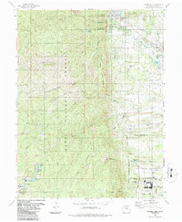
1986 Map of Palmer Lake
USGS Topo · Published 1986About this map
The United States Air Force Academy occupies the southeastern corner of this landscape, a significant institutional presence defined by its Planetarium, Athletic Fields, and Parade Ground. North of the academy grounds, the settlements of Palmer Lake and Monument serve as hubs of local activity. The corridor between them follows the Denver and Rio Grande Western Railroad Grade, reflecting the importance of this rail line to the region's development along the mountain front. To the west, the Pike National Forest covers the high terrain, marked by prominent peaks like Mount Herman and Sundance Mountain. This wilderness area is laced with recreational routes including the Winding Stairs Trail and Schubarth Trail, which lead to high-altitude water bodies such as Rainbow Lake and Columbine Lake. The map also details the Farish Memorial Recreation Area (USAFA), illustrating the shared use of the forest for military training and public recreation.
Find a feature on this map
61 named features on this map. Tap any name to fly to it.
Don’t see what you’re looking for? This feature index may not catch every label — zoom into the map to look around manually.
Map Details
Editions of this 1986 Palmer Lake Map
This is the sole edition of this map. No revisions or reprints were ever made.
Other maps of this area

1893 · Platte Canyon
USGS Topo · 1:125,000

1893 · Colorado Springs
USGS Topo · 1:125,000

1894 · Pikes Peak
USGS Topo · 1:125,000

1894 · Castle Rock
USGS Topo · 1:125,000

1901 · Pikes Peak
USGS Topo · 1:125,000

1901 · Pikes Peak
USGS Topo · 1:62,500

1909 · Colorado Springs
USGS Topo · 1:125,000

1913 · Castle Rock
USGS Topo · 1:125,000

1942 · Colorado Springs
USGS Topo · 1:125,000

1948 · Colorado Springs
USGS Topo · 1:62,500