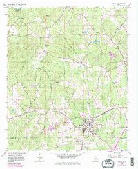
1954 Map of Palmetto
USGS Topo · Published 1983About this map
The town of Palmetto serves as the focal point of this mid-century topographic survey, situated at the intersection of the Atlanta and West Point railroad and the Roosevelt Highway and West Point. The landscape is defined by the drainage systems of Bear Creek and Pea Creek, which flow toward the northwest corner where Rivertown sits near the Chattahoochee River. Rural life in this era is evidenced by several community hubs, including the Georgia Baptist Childrens Home, the South Fulton Skyport, and a network of country schools such as Riley Sch and Cedar Grove Sch. The map reveals a transition into the early 1980s via purple revisions that show the emergence of Interchange 85, illustrating how modern infrastructure began to overlay the older agricultural and ecclesiastical patterns established by congregations at Antioch Ch and Bethlehem Ch.
Find a feature on this map
43 named features on this map. Tap any name to fly to it.
Don’t see what you’re looking for? This feature index may not catch every label — zoom into the map to look around manually.
Map Details
Editions of this 1954 Palmetto Map
4 editions found
Other maps of this area

1891 · Marietta
USGS Topo · 1:125,000

1895 · Marietta
USGS Topo · 1:125,000

1897 · Marietta
USGS Topo · 1:125,000

1901 · Marietta
USGS Topo · 1:125,000

1953 · Atlanta
USGS Topo · 1:250,000

1954 · Palmetto
USGS Topo · 1:24,000

1954 · Campbellton
USGS Topo · 1:24,000

1954 · Fairburn
USGS Topo · 1:24,000
1954 · Ben Hill
USGS Topo · 1:24,000

1957 · Atlanta
USGS Topo · 1:250,000