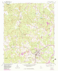
1954 Map of Palmetto
USGS Topo · Published 1983About this map
The Chattahoochee River marks the northwestern boundary of this 1950s Georgia landscape, where agricultural tradition met mid-century infrastructure. Near the settled community of Palmetto, the Central Of Georgia railroad and the Roosevelt Highway And West Point corridor define the local transit network. The area is dotted with civic and religious landmarks essential for genealogical research, including the Georgia Baptist Childrens Home and several rural congregations such as Antioch Ch and St Pauls Ch.
Find a feature on this map
31 named features on this map. Tap any name to fly to it.
Don’t see what you’re looking for? This feature index may not catch every label — zoom into the map to look around manually.
Map Details
Editions of this 1954 Palmetto Map
4 editions found
Other maps of this area

1891 · Marietta
USGS Topo · 1:125,000

1895 · Marietta
USGS Topo · 1:125,000

1897 · Marietta
USGS Topo · 1:125,000

1901 · Marietta
USGS Topo · 1:125,000

1953 · Atlanta
USGS Topo · 1:250,000

1954 · Palmetto
USGS Topo · 1:24,000

1954 · Campbellton
USGS Topo · 1:24,000

1954 · Fairburn
USGS Topo · 1:24,000
1954 · Ben Hill
USGS Topo · 1:24,000

1957 · Atlanta
USGS Topo · 1:250,000