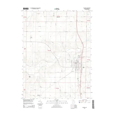
2015 Map of Palmyra
USGS Topo · Published 2015About this map
Palmyra serves as the central hub of this Marion County region, where a structured grid of streets meets the winding paths of the North River and the South River. The landscape is defined by the convergence of several waterways, including the South Fabius River and Lick Cr, which carve through the terrain surrounding smaller settlements like Smileyville and Dodge City. Local history is anchored by sites like Greenwood Cemetery on the edge of the main town and rural burial grounds such as Bethel Cemetery and Pleasant Grove Cemetery. A mix of natural and man-made water features, from the Sears Community Lake to the Number 12 Reservoir, suggests a landscape managed for both utility and recreation. The presence of Slees Mills and Woodland further illustrates the distribution of smaller communities across the township and range divisions, connected by an extensive network of county roads.
Find a feature on this map
80 named features on this map. Tap any name to fly to it.
Don’t see what you’re looking for? This feature index may not catch every label — zoom into the map to look around manually.
Map Details
Editions of this 2015 Palmyra Map
This is the sole edition of this map. No revisions or reprints were ever made.
Other maps of this area

1903 · Palmyra
USGS Topo · 1:125,000

1925 · Quincy
USGS Topo · 1:62,500

1932 · Hannibal
USGS Topo · 1:62,500

1936 · Hannibal
USGS Topo · 1:48,000

1944 · Quincy
USGS Topo · 1:62,500

1945 · Hannibal
USGS Topo · 1:62,500

1945 · Quincy
USGS Topo · 1:62,500

1948 · Quincy
USGS Topo · 1:250,000

1949 · Durham
USGS Topo · 1:24,000

1949 · Maywood
USGS Topo · 1:24,000