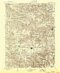
1903 Map of Palmyra
USGS Topo · Published 1943About this map
Palmyra serves as the focal point for this Northeastern Missouri landscape, where the convergence of rail lines and river valleys defined local commerce at the start of the 1900s. The survey captures a high density of rural townships like Round Grove and Tiger Fork, punctuated by numerous small post offices and settlements such as Philadelphia and Steffenville. The transportation network is particularly prominent, featuring the Hannibal and St Joseph R R and the Quincy Omaha and Kansas City R R, which provided vital links for agricultural exports. Along the waterways, including the Middle Fabius River and the winding Salt River, industry is visible through sites like Slees Mills. For those tracing family history, the map provides precise locations for local landmarks such as St Pauls Ch and scattered communities like Rensselaer and Hunnewell.
Find a feature on this map
87 named features on this map. Tap any name to fly to it.
Don’t see what you’re looking for? This feature index may not catch every label — zoom into the map to look around manually.
Map Details
Editions of this 1903 Palmyra Map
2 editions found
Other maps of this area

1890 · Louisiana
USGS Topo · 1:125,000

1890 · Mexico
USGS Topo · 1:125,000

1890 · Moberly
USGS Topo · 1:125,000

1903 · Kahoka
USGS Topo · 1:125,000

1903 · Palmyra
USGS Topo · 1:125,000

1903 · Edina
USGS Topo · 1:125,000

1925 · Quincy
USGS Topo · 1:62,500

1932 · Hannibal
USGS Topo · 1:62,500

1936 · Hannibal
USGS Topo · 1:48,000

1943 · Vandalia
USGS Topo · 1:62,500