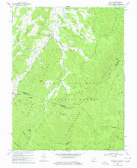
1969 Map of Palo Alto
USGS Topo · Published 1977About this map
Sugar Grove Ridge and Shenandoah Mountain dominate this late-1960s landscape, which spans the high border country between West Virginia and Virginia. The settlement of Palo Alto sits in the shadows of Simmons Mtn and Buffalo Knob, serving as a focal point for a region defined by its steep hollows and ridges. Several community landmarks appear, including Wilfong Ch near the Potomac River, and Crummett Ch located further west along Crummett Run. The topography is marked by a complex drainage system where Brushy Fork and Flesher Run carve through the terrain. Evidence of water management for the time is visible through a series of engineered structures such as Dam No 36 and Dam No 18 on Stony Run, while the expansive George Washington National Forest covers much of the southeastern portion of the map, illustrating the intersection of private homesteads and federal land.
Find a feature on this map
59 named features on this map. Tap any name to fly to it.
Don’t see what you’re looking for? This feature index may not catch every label — zoom into the map to look around manually.
Map Details
Editions of this 1969 Palo Alto Map
3 editions found
Other maps of this area

1892 · Franklin
USGS Topo · 1:125,000

1894 · Staunton
USGS Topo · 1:125,000

1896 · Franklin
USGS Topo · 1:125,000

1922 · Fort Seybert
USGS Topo · 1:48,000

1922 · Circleville
USGS Topo · 1:62,500

1924 · Circleville
USGS Topo · 1:48,000

1924 · Mc Dowell
USGS Topo · 1:62,500

1924 · Fort Seybert
USGS Topo · 1:62,500

1944 · Parnassus
USGS Topo · 1:62,500

1944 · Mc Dowell
USGS Topo · 1:62,500