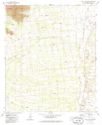
1979 Map of Palo Alto Ranch
USGS Topo · Published 1979About this map
The eastern foothills of the Coyote Mountains dominate the northwestern corner of this quadrangle, giving way to a landscape defined by an intricate network of desert washes and ranching infrastructure. Arid-land water management is central to the area's development, evidenced by numerous livestock watering sites such as San Pedro Tank, Lievres Tank, and Chico Tank. The Alambre Trail and various unnamed Jeep Trails provide the primary means of traversal across the alluvial fans of Mendoza Wash and Altar Wash.
Find a feature on this map
34 named features on this map. Tap any name to fly to it.
Don’t see what you’re looking for? This feature index may not catch every label — zoom into the map to look around manually.
Map Details
Editions of this 1979 Palo Alto Ranch Map
2 editions found
Other maps of this area

1920 · Arivaca
USGS Topo · 1:125,000

1934 · Tucson Mountains
USGS Topo · 1:125,000

1934 · Silver Bell
USGS Topo · 1:125,000

1938 · San Vicente
USGS Topo · 1:62,500

1940 · Palo Alto Ranch
USGS Topo · 1:62,500

1941 · San Vicente
USGS Topo · 1:62,500

1941 · Cocoraque Butte
USGS Topo · 1:62,500

1941 · Baboquivari Peak
USGS Topo · 1:62,500

1942 · San Vicente
USGS Topo · 1:62,500

1943 · Cocoraque Butte
USGS Topo · 1:62,500