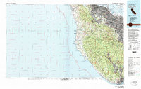
1982 Map of Palo Alto
USGS Topo · Published 1984About this map
The Santa Cruz Mountains dominate the central spine of this map, separating the densely populated Santa Clara Valley from the rugged Pacific coastline in the early 1980s. Along the San Francisco Bay, the landscape is defined by massive infrastructure and suburban expansion, including Moffett Field and the Southern Pacific railroad corridor connecting Redwood City, Palo Alto, and San Jose. In contrast, the western slopes descend into a series of protected landscapes such as Big Basin Redwoods State Park and Butano State Park. This transition from the urban Silicon Valley core to coastal agricultural outposts like Pescadero and San Gregorio illustrates the geographical divide that shaped the region's development. Coastal landmarks like the Pigeon Point Lighthouse and Año Nuevo Island provide fixed points for navigating a shoreline defined by dramatic points and beaches.
Find a feature on this map
72 named features on this map. Tap any name to fly to it.
Don’t see what you’re looking for? This feature index may not catch every label — zoom into the map to look around manually.
Map Details
Editions of this 1982 Palo Alto Map
2 editions found
Other maps of this area

1889 · San Jose
USGS Topo · 1:62,500

1892 · San Mateo
USGS Topo · 1:62,500

1896 · San Mateo
USGS Topo · 1:62,500

1897 · San Jose
USGS Topo · 1:62,500

1897 · Palo Alto
USGS Topo · 1:62,500

1899 · San Jose
USGS Topo · 1:62,500

1899 · Palo Alto
USGS Topo · 1:62,500

1899 · Haywards
USGS Topo · 1:62,500

1899 · San Mateo
USGS Topo · 1:62,500

1902 · Santa Cruz
USGS Topo · 1:125,000