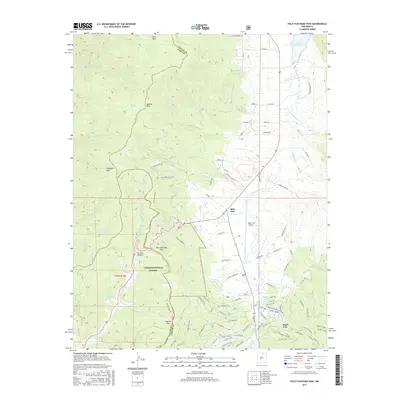
2017 Map of Palo Flechado Pass
USGS Topo · Published 2017About this map
Palo Flechado Pass serves as a critical geographic marker in the high country of the Carson National Forest, bridging the divide between Colfax and Taos counties. This 2017 survey shows the modern footprint of Angel Fire, with its residential road networks like Valle Grande Trl N and Saddleback Trl sprawling near the Angel Fire Airport. The drainage patterns are clearly defined, with the Rio Pueblo de Taos and Rio Fernando de Taos flowing through the western slopes while Cieneguilla Cr feeds toward Eagle Nest Lake to the northeast. Notable landmarks such as Apache Peak and Witt Park anchor the high-elevation terrain, while the settlement of Agua Fria marks the convergence of Ninemile Cr and W Agua Fria Cr.
Find a feature on this map
100 named features on this map. Tap any name to fly to it.
Don’t see what you’re looking for? This feature index may not catch every label — zoom into the map to look around manually.
Map Details
Editions of this 2017 Palo Flechado Pass Map
This is the sole edition of this map. No revisions or reprints were ever made.
Other maps of this area

1954 · Raton
USGS Topo · 1:250,000

1955 · Ute Park
USGS Topo · 1:62,500

1956 · Tooth Of Time
USGS Topo · 1:62,500

1958 · Raton
USGS Topo · 1:250,000

1963 · Wheeler Peak
USGS Topo · 1:24,000

1963 · Eagle Nest
USGS Topo · 1:24,000

1965 · Osha Mountain
USGS Topo · 1:24,000

1965 · Palo Flechado Pass
USGS Topo · 1:24,000

1965 · Pueblo Peak
USGS Topo · 1:24,000

1965 · Shady Brook
USGS Topo · 1:24,000