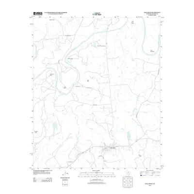
2012 Map of Palo Pinto
USGS Topo · Published 2012About this map
Palo Pinto serves as the focal point of this North Texas survey, situated along the southern edge of a landscape defined by the winding course of the Brazos River. The river creates a series of dramatic loops including Crawford Bend, Dalton Bend, and Chick Bend, which dictate the local road network and cattle ranching boundaries. Upland areas such as Rocky Prairie and local peaks like Kyle Mtn and Crawford Mtn break the terrain, while smaller waterways like Elm Cr and Wolf Br drain into the Brazos. Significant ranching heritage is evident through named features like Worth Ranch and roads such as McMurrey Ranch Rd and Rhodes Ranch Rd. The presence of Costello Lake and the small settlement of Harris further mark this transition between the river valley and the surrounding Texas highlands.
Find a feature on this map
30 named features on this map. Tap any name to fly to it.
Don’t see what you’re looking for? This feature index may not catch every label — zoom into the map to look around manually.
Map Details
Editions of this 2012 Palo Pinto Map
This is the sole edition of this map. No revisions or reprints were ever made.
Other maps of this area

1891 · Palo Pinto
USGS Topo · 1:125,000

1918 · Palo Pinto
USGS Topo · 1:125,000

1924 · Palo Pinto 2-b
USGS Topo · 1:48,000

1924 · Palo Pinto 2-a
USGS Topo · 1:48,000

1924 · Palo Pinto 1-b
USGS Topo · 1:48,000

1924 · Palo Pinto 2-c
USGS Topo · 1:48,000

1925 · Palo Pinto 4-b
USGS Topo · 1:48,000

1927 · Pickwick
USGS Topo · 1:62,500

1927 · Mineral Wells
USGS Topo · 1:62,500

1931 · Santo
USGS Topo · 1:62,500