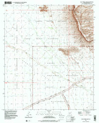
1996 Map of Palo Verde Camp
USGS Topo · Published 2000About this map
Organ Pipe Cactus National Monument meets the Cabeza Prieta National Wildlife Refuge in this arid desert landscape, defined by sharp boundaries between federal conservation lands and military territory. The eastern portion of the map is dominated by the steep rises of the Growler Mountains, which overlook the expansive Growler Valley to the west. Evidence of remote human activity is sparse, centered on the Palo Verde Camp and the isolated Drill Hole landmark. The desert floor is bisected by the ephemeral path of Growler Wash, which drains through the Cabeza Prieta Wilderness. Transportation is limited to a few primitive routes like Bates Well Road and Pozo Nuevo Road, which cross the high desert north of the Barry M. Goldwater Air Force Range, illustrating the intersection of military training grounds and protected wilderness areas in late-twentieth-century Arizona.
Find a feature on this map
17 named features on this map. Tap any name to fly to it.
Don’t see what you’re looking for? This feature index may not catch every label — zoom into the map to look around manually.
Map Details
Editions of this 1996 Palo Verde Camp Map
This is the sole edition of this map. No revisions or reprints were ever made.
Other maps of this area

1932 · Ajo
USGS Topo · 1:62,500

1934 · Ajo
USGS Topo · 1:62,500

1953 · Ajo
USGS Topo · 1:250,000

1957 · Ajo
USGS Topo · 1:250,000

1958 · Ajo
USGS Topo · 1:250,000

1962 · Ajo
USGS Topo · 1:250,000

1963 · Ajo
USGS Topo · 1:250,000

1963 · Ajo
USGS Topo · 1:62,500

1963 · Kino Peak
USGS Topo · 1:62,500

1964 · Growler Peak
USGS Topo · 1:62,500