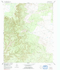
1963 Map of Paloduro
USGS Topo · Published 1991About this map
Paloduro sits at a geographic crossroads where the high plains of the Texas Panhandle drop away into the deeply eroded drainages of the Red River system. This 1963 survey, photoinspected in the late 1970s, captures a landscape defined by sharp elevation changes and seasonal watercourses. Notable landmarks like Koogle Jump Off and Mitchell Peak provide distinct vantage points over the complex network of canyons and gaps, including the descriptive Wagon Wheel Gap. The map illustrates a sparse settlement pattern typical of the region, where life is organized around the availability of water in ephemeral streams like West Fork Cottonwood Creek, Battle Creek, and Lone Tree Creek. Genealogists may find interest in the isolated Cem located near the eastern edge of the survey, while the presence of several benchmark points, such as BM 2772, indicates the precise geodetic work required to map this transition from flat plateau to carved canyon lands.
Find a feature on this map
19 named features on this map. Tap any name to fly to it.
Don’t see what you’re looking for? This feature index may not catch every label — zoom into the map to look around manually.
Map Details
Editions of this 1963 Paloduro Map
2 editions found
Other maps of this area

1954 · Plainview
USGS Topo · 1:250,000

1958 · Plainview
USGS Topo · 1:250,000

1960 · Indian Peak
USGS Topo · 1:62,500

1963 · Blue Hole Springs
USGS Topo · 1:24,000

1963 · Buffalo Arroyo
USGS Topo · 1:24,000

1963 · Luttrell Springs NE
USGS Topo · 1:24,000

1963 · Paloduro
USGS Topo · 1:24,000

1963 · Tate Arroyo
USGS Topo · 1:24,000
1963 · Gip Creek
USGS Topo · 1:24,000

1965 · Big Betty Reservoir
USGS Topo · 1:24,000