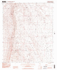
1996 Map of Palomas Gap
USGS Topo · Published 2002About this map
Caballo Mountains define the physical and industrial history of this Sierra County landscape, where the high peaks of Turtle Mountain and Caballo Cone overlook a complex system of drainage and resource extraction. The interior of the range is cut by deep landmarks such as Palomas Gap Canyon and Lead Mine Canyon, the latter of which leads directly to the named Lead Mine.
Find a feature on this map
20 named features on this map. Tap any name to fly to it.
Don’t see what you’re looking for? This feature index may not catch every label — zoom into the map to look around manually.
Map Details
Editions of this 1996 Palomas Gap Map
This is the sole edition of this map. No revisions or reprints were ever made.
Other maps of this area

1954 · Tularosa
USGS Topo · 1:250,000

1955 · Las Cruces
USGS Topo · 1:250,000

1958 · Las Cruces
USGS Topo · 1:250,000

1958 · Tularosa
USGS Topo · 1:250,000

1958 · Elephant Butte
USGS Topo · 1:24,000

1959 · Engle
USGS Topo · 1:62,500

1959 · Upham
USGS Topo · 1:62,500

1961 · Caballo
USGS Topo · 1:24,000

1961 · Williamsburg
USGS Topo · 1:24,000

1961 · Cuchillo
USGS Topo · 1:24,000