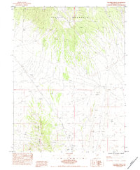
1984 Map of Palomino Ridge
USGS Topo · Published 1984About this map
Spruce Mountain dominates the northern landscape of this Elko County region, its high peaks and deep drainage systems defining the high-desert terrain. To the southwest, the lower elevations of Palomino Ridge provide a distinct contrast in the local topography. This 1984 provisional survey captures the area during a period of industrial utility, primarily marked by several Borrow Pit excavations scattered across the flats and slopes. These features suggest the practical needs of road maintenance and local construction in a remote part of Nevada. The map is primarily a study of natural landforms, showing the intricate network of washes and canyons that carve through the mountain range, illustrating the rugged character of the Great Basin during the late twentieth century.
Find a feature on this map
3 named features on this map. Tap any name to fly to it.
Don’t see what you’re looking for? This feature index may not catch every label — zoom into the map to look around manually.
Map Details
Editions of this 1984 Palomino Ridge Map
This is the sole edition of this map. No revisions or reprints were ever made.
Other maps of this area

1953 · Spruce Mountain
USGS Topo · 1:62,500

1953 · Spruce Mountain 4
USGS Topo · 1:62,500

1955 · Elko
USGS Topo · 1:250,000

1958 · Elko
USGS Topo · 1:250,000

1962 · Elko
USGS Topo · 1:250,000

1965 · Elko
USGS Topo · 1:250,000

1982 · Currie
USGS Topo · 1:24,000

1982 · Mizpah
USGS Topo · 1:24,000

1984 · Currie Gardens
USGS Topo · 1:24,000

1984 · Silo Canyon
USGS Topo · 1:24,000