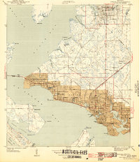
1943 Map of Panama City
USGS Topo · Published 1943About this map
St Andrews Bay and its intricate network of inlets define this coastal landscape as it appeared during the height of the Second World War. The urban core of Panama City is captured alongside its neighboring communities, showing a concentrated grid of development around Massalina Bayou and Bunkers Cove. At this time, the Atlanta and St Andrews Bay railroad served as a critical corridor for the region's industry, connecting the waterfront to inland markets.
Find a feature on this map
53 named features on this map. Tap any name to fly to it.
Don’t see what you’re looking for? This feature index may not catch every label — zoom into the map to look around manually.
Map Details
Editions of this 1943 Panama City Map
3 editions found
Other maps of this area

1943 · Beacon Beach
USGS Topo · 1:31,680

1943 · Panama City
USGS Topo · 1:31,680

1943 · Panama City Beach
USGS Topo · 1:31,680

1943 · West Bay
USGS Topo · 1:24,000

1943 · Southport
USGS Topo · 1:24,000

1944 · Southport
USGS Topo · 1:24,000

1944 · West Bay
USGS Topo · 1:31,680

1944 · Long Point
USGS Topo · 1:31,680

1944 · Bayhead
USGS Topo · 1:24,000

1945 · Bayhead
USGS Topo · 1:31,680