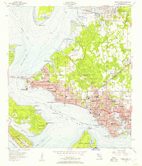
1956 Map of Panama City
USGS Topo · Published 1957About this map
Panama City is the hub of this mid-1950s coastal survey, revealing a landscape defined by the intricate fingers of St Andrews Bay and the industrial activity of the Atlanta and St Andrews Bay railroad. The map shows the city expanding into distinct neighborhoods like Glenwood, Millville, and Cedar Grove, while the waterfront remains dominated by maritime infrastructure and military presence, including the US Military Reservation and part of Tyndall Air Force Base.
Find a feature on this map
83 named features on this map. Tap any name to fly to it.
Don’t see what you’re looking for? This feature index may not catch every label — zoom into the map to look around manually.
Map Details
Editions of this 1956 Panama City Map
2 editions found
Other maps of this area

1943 · Beacon Beach
USGS Topo · 1:31,680

1943 · Panama City
USGS Topo · 1:31,680

1943 · Panama City Beach
USGS Topo · 1:31,680

1943 · West Bay
USGS Topo · 1:24,000

1943 · Southport
USGS Topo · 1:24,000

1944 · Southport
USGS Topo · 1:24,000

1944 · West Bay
USGS Topo · 1:31,680

1944 · Long Point
USGS Topo · 1:31,680

1944 · Bayhead
USGS Topo · 1:24,000

1945 · Bayhead
USGS Topo · 1:31,680