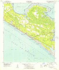
1955 Map of Panama City Beach
USGS Topo · Published 1957About this map
Panama City Beach and the surrounding coastline emerge as a series of distinct beachfront developments in the mid-1950s, connected by a strip of highway and secondary roads. This era shows the early tourism and residential footprint of the Emerald Coast, where established communities like Bid-A-Wee, Long Beach Resort, and Edgewater Gulf Beach occupy the narrow stretch between the Gulf of Mexico and the marshy expanses of West Bay. To the east, the landscape is shaped by military and social infrastructure, including the U S Naval Reservation and the County Juvenile Home. Local landmarks such as the Drive-in Theater and the Long Beach Ch reflect the growing community's social life. The intricate network of waterways, including Grand Lagoon and Botheration Bayou, highlights the complex coastal geography before major modern alterations.
Find a feature on this map
27 named features on this map. Tap any name to fly to it.
Don’t see what you’re looking for? This feature index may not catch every label — zoom into the map to look around manually.
Map Details
Editions of this 1955 Panama City Beach Map
2 editions found
Other maps of this area

1943 · Beacon Beach
USGS Topo · 1:31,680

1943 · Laguna Beach
USGS Topo · 1:31,680

1943 · Panama City
USGS Topo · 1:31,680

1943 · Panama City Beach
USGS Topo · 1:31,680

1943 · Seminole Hills
USGS Topo · 1:24,000

1943 · West Bay
USGS Topo · 1:24,000

1943 · Southport
USGS Topo · 1:24,000

1944 · Southport
USGS Topo · 1:24,000

1944 · Seminole Hills
USGS Topo · 1:31,680

1944 · West Bay
USGS Topo · 1:31,680
Featured Places
- Panama City Beach, FL
- Lower Grand Lagoon, FL
- Biltmore Beach, FL
- Edgewater Gulf Beach, Panama City Beach
- Florida Beach, Panama City Beach