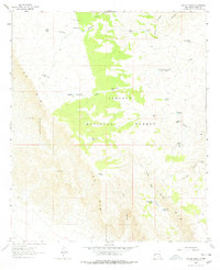
1963 Map of Panama Ranch
USGS Topo · Published 1978About this map
Panama Ranch and the small settlement of Panama anchor this high-elevation landscape in Otero County, where ranching infrastructure defines the use of the land. The topography is dominated by the dramatic escarpment of The Rim, which cuts through the western portion of the quadrangle. The area is heavily managed for water, evidenced by a dense network of catchment features including Jones Farm Tank, Bates Park Tank, and Lower Frijole Tank.
Find a feature on this map
31 named features on this map. Tap any name to fly to it.
Don’t see what you’re looking for? This feature index may not catch every label — zoom into the map to look around manually.
Map Details
Editions of this 1963 Panama Ranch Map
2 editions found
Other maps of this area

1943 · Texas Hill
USGS Topo · 1:62,500

1945 · Texas Hill
USGS Topo · 1:62,500

1954 · Carlsbad
USGS Topo · 1:250,000

1958 · Carlsbad
USGS Topo · 1:250,000

1963 · Hackberry Hill
USGS Topo · 1:24,000

1963 · Tanner Ranch
USGS Topo · 1:24,000

1963 · Gowdy Ranch
USGS Topo · 1:24,000

1963 · Panama Ranch
USGS Topo · 1:24,000

1965 · Bullis Spring Ranch
USGS Topo · 1:24,000

1965 · Pinon Ranch
USGS Topo · 1:24,000